Exact date 597-mile long wall of rain will hit after weekend weather washout
A huge 'wall' of rain is set to hit the UK in just a few days after a weekend of washout weather.
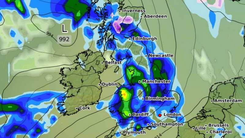
New weather maps from WXCharts show the large front sweeping in from the Atlantic on Tuesday, leaving many parts of the country drenched and others blanketed with snow.
Torrential downpours could see 5-6mm of rain fall per hour in the worst-affected areas. The rain is forecast to arrive in Northern Ireland in the early hours of Tuesday, moving to Wales and Scotland by lunchtime and ending the day in East Anglia.
This band of wet and wintry weather will stretch from Plymouth to Fort William in Scotland - approximately 597 miles.
 Weather map for Tuesday 12 March (WX Charts)
Mother's Day this Sunday is also looking likely to be a rainy affair, with forecasters warning that any plans for a family walk in the park may have to contend with rain and high winds. In her latest weather overview for this weekend, TV weather expert Jo Farrow wrote on Netweather: "The forecast isn’t looking great for Sunday morning. The winds will have dropped for southern England but the easterly continues to make its presence felt further north. It will feel chilly for Scotland away from sheltered areas and along the North Sea coast of England."
 Gales, snow and rain to batter country today with 80mph wind gusts
The Met Office has said that lower pressure will start to push in from the south on Saturday, accompanied by "brisk winds". Their forecast reads: "Showery rain pushing northwards with a few showers elsewhere and some brighter spells in-between. Remaining windy, making it feel chilly, particularly in the north". Temperatures will reach a maximum of around 12C in the south of England, dropping to around 6-7C further north. Sunday will then be "widely unsettled", with frequent outbreaks of rain and showers.
Further ahead, forecasters have warned of a rare weather event which could see some of the coldest weather of the winter so far. A Sudden Stratospheric Warming (SSW) is 'underway' high up in the atmosphere, according to meteorologists, and could soon bring 'widespread snow' and a distinctly cold feel from around the start of next week.
UK weather forecast
Saturday:
Remaining unsettled on Saturday with showers continuing to spread northeast through the day. Cloudy for most, although some brighter spells possible at times. Brisk easterly winds making it feel cold.
Outlook for Sunday to Tuesday:
Rain becoming more widespread on Sunday. Turning drier from the west through Monday, and winds easing. Dry for most on Tuesday, before rain and cloud arrives from the west later.
Read more similar news:
Comments:
comments powered by Disqus