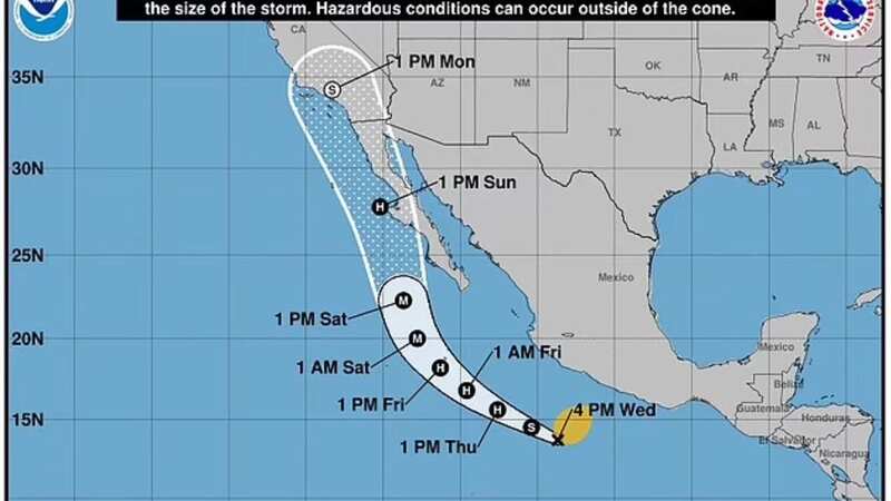
National Hurricane Center tracker map shows tropical cyclone Storm Hilary's path

A chilling National Hurricane Center tracker map shows the tropical cyclone Storm Hilary's path and when it is set to hit the US.
Tropical Storm Hilary formed on Wednesday southwest of Mexico and according to the National Hurricane Center it looks set to become a hurricane hitting western parts of the US.
An advisory bulletin posted at 3am Mountain Daylight Time (MDT) from the National Hurricane Center (NHC) in Miami, Florida, warned: "Hilary forecast to rapidly intensify and become a hurricane very soon... Tropical storm watch issued for the southern portion of Baja California Sur."
According to the centre, Tropical Storm Hilary is moving northward and "rapid strengthening is forecast", meaning it will become a hurricane soon. Maximum sustained wind speeds have increased to near 70mph, with higher gusts, and the NHC warns: "It could become a major hurricane by tonight or early Friday."
It's believed Hilary could top out at least at a Category 3 intensity in the next few days, expected to peak on Saturday with 120mph winds. However, it's thought it will likely weaken as it passes over the Baja Peninsula.
 Gales, snow and rain to batter country today with 80mph wind gusts
Even if the storm does weaken, it could still bring significant impacts to parts of California and the southwest. Daniel Swain, a climate scientist at the University of California at Los Angeles, warned "multiple years' worth of precipitation" could potentially fall in some of the driest areas.
"This does have the potential to be a very high impact event for portions of Southern California," said the San Diego National Weather Service. "There is still a degree of uncertainty in the forecast and more details will come on exact timing, location, and magnitude of impacts in the coming days."
 Tropical Storm Hilary is predicted to reach a Category 3 hurricane (David Guzman/EPA-EFE/REX/Shutterstock)
Tropical Storm Hilary is projected to move through California's coastal waters on Sunday night and Monday, with the National Weather Service San Diego warning there is "a potential for tropical storm strength sustained winds" in a Marine Weather Statement from 8.51pm Pacific Daylight Time (PDT) on Wednesday.
They said: "If these winds occur, they will be accompanied by large, steep seas of 10 to 15 feet with periods of 6 seconds or less. Thunderstorms with heavy rain and locally stronger winds could also occur with this storm.
"Even if the storm track deviates from its current forecast, there could still be impacts to the coastal waters with strong winds, high seas and thunderstorms. Mariners should be prepared for dangerous seas and are urged to seek safe harbour should life-threatening weather approach."
 Mariners are being warned of dangerous conditions due to strong winds and swells (AFP via Getty Images)
Tropical Storm Hilary is the eighth named storm of this year's Eastern Pacific hurricane season. Once winds reach around 74mph, a storm becomes a hurricane, and at 111mph it becomes a major hurricane.
Scientists have reached a general consensus that hurricanes are becoming more powerful due to climate change. While they predict there might not be more named storms overall, the likelihood of storms developing into major hurricanes is increasing.
A recorded storm has never made it to California as a hurricane, and there have only been three storms to make it into California as tropical storms - Nora in 1997, Kathleen in 1976, and Long Beach storm in 1939. Though tropical rain has been known to reach Southern California from the remnants of tropical storms and hurricanes, which still pose a danger.
Read more similar news:
Comments:
comments powered by Disqus


