New Year's Eve weather in your area as warning of 75mph gales
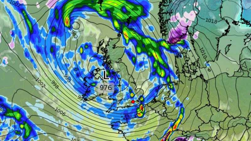
A New Year's Eve weather warning has been issued for parts of the UK with revellers told to expect high winds and rain during the countdown. Gusts of 50-55mph are likely across wide areas, with potential for speeds of 65-75mph, the Met Office says.
The most exposed coasts and hills on the southern coast of England and in South Wales will bear the brunt of the strong gusts. There could also be squally showers across the area and even the risk of hail and thunder.
The warning is in place until 12am on Sunday, with some delays to road, rail, air and ferry transport possible, forecasters said. In Scotland, Edinburgh will be cloudy but is expected to remain dry on Sunday evening for Hogmanay celebrations.
Scattered, blustery showers are expected to develop across the country throughout the day, possibly thundery along southern coasts, but some brighter spells are possible between showers.
Meteorologist Craig Snell said: "A blustery day especially across the south and the very far north east of the UK, and with the winds coming in from the north-west a cooler feeling day compared to Saturday but still just reaching double figures in the south.
 Gales, snow and rain to batter country today with 80mph wind gusts
"Then into the evening as we begin to approach midnight for many parts, Northern Ireland, England and Wales we continue to see some further showers, so certainly recommend a rain jacket if you are planning to be about around midnight.
"For Scotland it should turn a little but drier here and with some lighter winds, it will turn quite chilly too, so maybe a thicker jacket here as we approach midnight.
"Then for the rest of the night very little changes really, still the risk of some further showers, showers may well return across parts of Scotland too as we start the New Year's Day morning."
The last storm to hit the UK was named Gerrit on Boxing Day. The Met Office had confirmed the latest low pressure system, though blustery, will not be named. The French meteorological office has named a severe weather system hitting its shores as Storm Geraldine.
Here is a regional breakdown of the UK's New Year's Eve weather forecast courtesy of the Met Office:
North East
A largely dry start for many with some bright spells away from hills. Scattered showers developing through the morning, the best of any drier spells in the east. A light breeze throughout, perhaps a little blustery near showers. Cold. Maximum temperature 5 °C.
Showers continuing into the evening, though likely merging into a longer spell of rain in the south and over the Pennines overnight. Dry later further north. Winds increasing later. Cold. Minimum temperature 1 °C.
North West
Scattered heavy showers spreading east, perhaps merging into bands at times with an isolated thunderstorm possible. Lighter winds than yesterday but still quite gusty winds around the showers. Feeling a bit colder. Turning windier with frequent heavy showers this evening. Maximum temperature 8 °C.
A showery evening and start to the new year with showers continuing overnight, merging into longer spells of rain in places. Windy with coastal gales possible in the south. Minimum temperature 4 °C.
Yorkshire and Humber
Rain clearing northeastwards initially. Becoming largely dry with some brighter spells. Scattered showers developing over the Pennines and moving east from midday, driest toward eastern coasts. A moderate breeze throughout, perhaps a little blustery near showers. Chilly. Maximum temperature 7 °C.
 Weather maps forecast 750-mile blizzard dropping three inches of snow next week
Showers continuing into the evening, though likely merging into a longer spell of rain toward midnight. Dry later in the east as winds strengthen. Cold. Minimum temperature 2 °C.
East Midlands
Rain clearing northeastwards initially. Becoming largely dry with some brighter spells. Scattered showers developing over the Peak District and moving east from midday, driest toward eastern coasts. A moderate breeze throughout, perhaps a little blustery near showers. Chilly. Maximum temperature 8 °C.
Showers continuing into the evening, though likely merging into a longer spell of rain toward midnight. Dry later in the east as winds strengthen. Cold. Minimum temperature 4 °C.
West Midlands
Sunshine and blustery showers, these heavy in places, perhaps with hail and an isolated rumble of thunder. Breezy at times with gusty winds around the showers. Feeling a bit colder. Maximum temperature 8 °C.
Turning rather windy this evening with an ongoing chance of showers, these locally briefly heavy. Fewer showers as we move into 2024, with more numerous clear spells developing. Minimum temperature 4 °C.
East of England
Rain clearing northeastwards initially. Becoming largely dry with some brighter spells. Turning cloudy with scattered showers moving east from late morning, driest toward eastern coasts. Windy throughout, blustery near showers. Chilly. Maximum temperature 9 °C.
Showers continuing into the evening, though generally easing later with most places dry and clear by midnight. Winds strengthening overnight. Cold. Minimum temperature 4 °C.
London
Rain clearing eastwards around dawn. Becoming largely dry for the first few hours before scattered heavy and blustery showers move east. Perhaps drier into the afternoon. Windy throughout, especially near showers. Cool. Maximum temperature 9 °C.
Scattered showers continuing into the evening, though generally easing later with most places dry and clear by midnight. Winds strong throughout. Cold. Minimum temperature 4 °C.
South West
Another windy day with sunny intervals and heavy blustery showers, possibly merging into bands at times with hail and thunder in places. Gales are likely in some coastal regions and feeling colder than yesterday, especially in the wind. Maximum temperature 10 °C.
Staying windy this evening with coastal gales and further heavy showers for many, perhaps locally thundery. Staying showery as we move into 2024, but some places turning mostly dry. Minimum temperature 5 °C.
Wales
Another windy day with sunny intervals and heavy blustery showers, possibly merging into bands at times with hail and thunder in places. Gales are likely in some coastal regions and feeling colder than yesterday, especially in the wind. Maximum temperature 9 °C.
Staying windy this evening with coastal gales and further heavy showers for many, perhaps locally thundery. Staying showery as we move into 2024, but becoming somewhat drier by the morning. Minimum temperature 3 °C.
Scotland
A mix of brighter spells and showers. Best of the brightness in the morning, particularly to the west of the A9. Winds light mainly from the east. Maximum temperature 8 °C.
Rather cloudy with showers, these turning quite frequent overnight. Winds light combining with clear spells to bring a frost most come dawn. Minimum temperature -2 °C.
Northern Ireland
Mainly cloudy with frequent showers, some turning heavy. Best of the limited brighter spells expected late in the day. Winds turning westerly and increasing strong during the afternoon, perhaps touching gale across Down coasts. Maximum temperature 8 °C.
A cloudy and showery evening, then turning drier from the west overnight with some brighter spells come dawn. Winds westerly fresh to strong. Minimum temperature 0 °C.
Read more similar news:
Comments:
comments powered by Disqus