Major update on snow forecast as icy snap set to sweep the UK within days
Parts of Britain could be blanketed by snow in just a week, as weather maps show an icy snap is on the way.
According to WXCharts, an easterly freeze is moving in from early December. Furthermore, snow coming from the north east is set to hit the UK too. Maps show a purple cyclone, representing snowfall, engulfing a large section of England's eastern coast on Friday, December 1.
Snow could fall as far south as Essex, south London and Surrey, according to weather maps. Forecasters said a total of seven inches of snow may fall in mainland Scotland, with more than double that coating the Scottish Highlands as temperatures dip to -7C at around midday.
 A woman walks a dog amongst frost covered vegetation in Bushy Park in London last year (PA)
The severity somewhat lessens the further south it hits, with Birmingham being the largest city set to see at least one inch of snow on the ground, reports the Express. Other maps show snowfall covering the south and south east, it currently looks as though it may not lay. Much of England will see highs of 2C on this day, with Scotland being the only place to struggle with a sub-zero mercury.
The Met Office's long-range weather forecast from November 29 to December 8 says temperatures will be "colder than average" and winds from the north will cause "a mixture of cold, quiet periods and some more showery episodes with rain, sleet and possibly hill snow." It adds: "Any sleet and snow showers would be most likely to affect northern and eastern coastal districts.
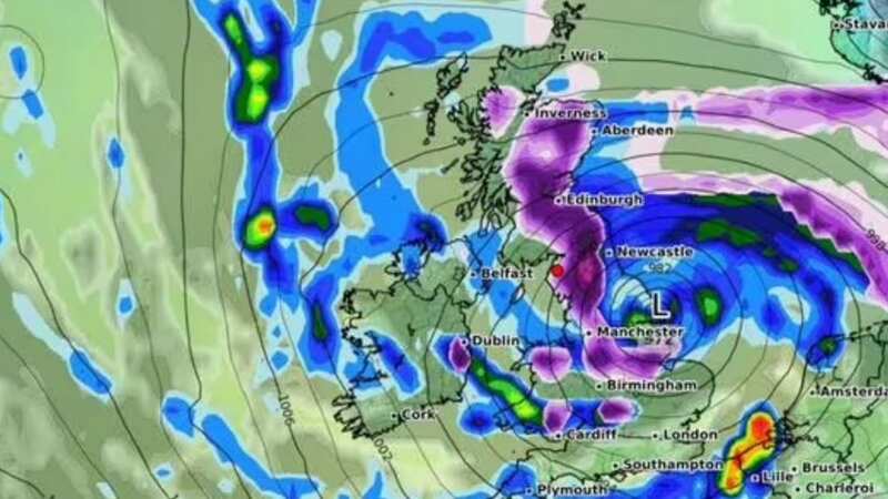
 Gales, snow and rain to batter country today with 80mph wind gusts
"There remains a chance of more widespread snow spreading up from the south during at least the first part of this period, should this occur strong winds or even gales are possible across many parts, especially the south. Colder weather could persist throughout, however towards the end of the period there is an increasing likelihood of an upward trend in temperatures as new areas of cloud and rain attempt to move in from the Atlantic."
It comes as the Met Office urged Brits to wrap up warm as the first frost of the year is set to hit tonight after freezing temperatures plummeted to a mere -5C. The warning comes after the bitter temperatures even targeted the rural parts of southern England, however, despite the severe cold weather, it will largely remain dry through Friday and Saturday, with showers only expected on the east coast.
Forecasters highlighted wetter interludes will push from the west and north on Sunday afternoon and into the start of next week - meaning more people will experience wet conditions. Fortunately, they said the weather will clear to the south and southeast later on Monday.
The latest alert follows the announcement of possible snow, as forecasters said northern Scotland could experience a snow blitz after a plunge in temperatures. Senior Meteorologist Greg Dewhurt told The Mirror: "The vast majority of places probably won't see any snow, especially for the next few days. There will be some snow showers across northern Scotland in particular the far northeast of Scotland. But there are also some very strong winds here, which will probably limit accumulations in places so there could be a few centimetres over the Scottish mountains and the northern Isles but otherwise, generally for most it's dry and if the cloud is thick enough, it will be light showers of rain really."
Brits hoping for a white Christmas had their hopes raised earlier this week when the forecaster said there is a strong possibility of "showers of a wintry flavour" - but a deep dive into the end of next month has dampened spirits. Things will be colder than average in the build-up, but only until the second week, according to the Met Office's long-range forecast up until December 23.
According to the Met Office, just one snowflake falling somewhere in the UK on December 25 is enough to classify that year as one - but looking outside to see your street blanketed in snow on the big day is now looking a less attractive bet. The weather experts said: "Generally temperatures are most likely to be near or above average, whilst short-lived colder interludes remain possible."
UK 5 day weather forecast
This Evening and Tonight:
Windy with scattered showers across northeast Scotland and at times Norfolk and Suffolk. Dry and clear elsewhere leading to a widespread frost, particularly across western areas.
Saturday:
After a cold frosty start, it will be a mainly dry day with light winds and plenty of sunny spells. Isolated showers along eastern coasts. A cold feeling day.
Outlook for Sunday to Tuesday:
A frosty start, then turning cloudier on Sunday with some rain possible. A similar day on Monday, before some brighter skies develop on Tuesday. Staying cold throughout.
Read more similar news:
Comments:
comments powered by Disqus